
Antique Prints, Maps, & Books of Natural History, Botanicals, & More
Lot 9859:
Description
Full Title:
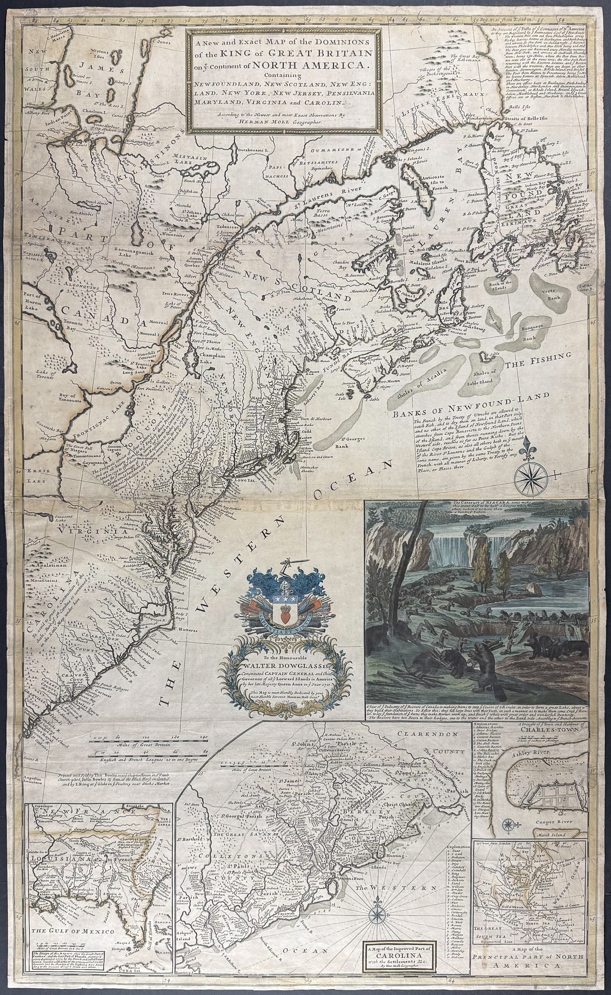
A New and Exact Map of the Dominions of the King of Great Britain on ye continent of North America containing Newfoundland, New Scotland, New England, New York, New Jersey, Pensilvania, Maryland, Virginia and Carolina. According to the newest and most exact observations
Description of the work:
This exceptional, important engraved map is Herman Moll’s
A New and Exact Map of the Dominions of the King of Great Britain on ye continent of North America containing Newfoundland, New Scotland, New England, New York, New Jersey, Pensilvania, Maryland, Virginia and Carolina. According to the newest and most exact observations. The map was published in London in 1715 [but after 1730] by John Bowles & Son "Printed and Sold by Tho: Bowles … John Bowles & Son … I. King at ye Globe in ye Poultry near Stocks Market."
This is the famous Beaver map. There is a large vignette which gives the map its moniker. The view shows Niagara Falls and a colony of beavers at work in the foreground. The beaver was a prominent symbol of the fur trade especially in maps.
There are additional insets of Carolina, Florida and the deep South (based on Thomas Nairne), and the Indian agent for South Carolina. It denotes territorial claims, Indian tribes, the fur trade, and condition of the land. It also shows early postal routs in the colonies, and also often referred to the ‘first American postal map.’
"One of the first and most important cartographic documents relating to the ongoing dispute between France and Great Britain over boundaries separating their respective American colonies … The map was the primary exponent of the British position during the period immediately following the Treaty of Utrecht in 1713." (Degrees of Latitude) The map denotes territory south of the St. Lawrence River and eastern Great Lakes as British.
Herman Moll (1654-1732) was a skilled cartographer and publisher based in London and Holland. He got his start as an engraver for Moses Pitt and other London map publishers. Moll is said to have made the bold claim that without a doubt “California is an Island.” He was contemporaries with Robert Boyle, Robert Hooke, and William Dampier.
Paper Size: ~ 41 1/2" by 24 7/8" (Fold Out on Two Joined Sheets)
Paper Type or Special Features: Engraving with Some Original Outline Color with Beaver Inset in Full Original Hand-coloring
Condition report:
The work is in very good to excellent condition overall. There is some expert restoration to the map. There may be a few minor imperfections or faint marks to be expected with age. Please review the image carefully for condition and contact us with any questions.
Share this lot: