
Antique Prints, Maps, & Books of Natural History, Botanicals, & More
Lot 6076:
Description
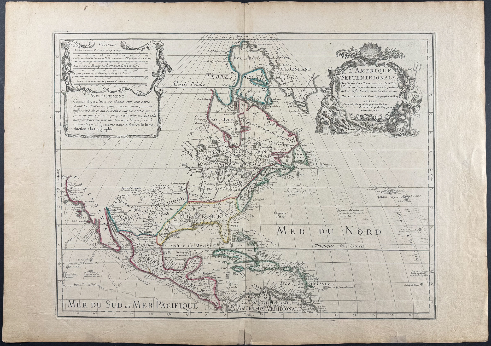
This engraved map of North America from Guillaume de l’Isle is entitled
L’Amérique septentrionale. This is the seventh state of the map and was published in Paris in 1718.
This was an important map that helped transform cartography of North America by correctly positioning the mouth of the Mississippi River. The map was first issued in 1700, but became more historically important in the second state with he placement of the Mississippi River mouth. The map features a beautiful cartouche engraved by Nicolas Guerard. The map is also the first to depict the Sargasso Sea in the Atlantic Ocean.
Burden explains: “… The first state shows significant differences throughout the Mississippi Valley. It was not until 1984 that the existence of the true first state became known, when it was discovered in a composite atlas in a private collection in Austria. That atlas contained the first states of each of De L’Isle’s five major maps of the Americas. Once its existence was recognized, other examples surfaced; five are known today.
Claude De L’Isle is also thought to be the author of a letter to Cassini concerning the mouth of the Mississippi. In it, he describes how, on his new map, the mouth is placed five degrees east of the Rio Bravo. This is the case on the first state, but it was altered for the second. He cites his authorities, noting that he had studied Chrestien Le Clerc’s account of Sieur La Salle’s voyages and the writings of Father Louis Hennepin. He also had access to documents from Pierre Le Moyne d’Iberville’s expedition of 1698–99—one coastal chart and two letters—as well as another map by M. de Chateaumorand, all indicating that the mouth of the Mississippi lay about 100 leagues east-northeast of the Rio Bravo. In the printed version, the identification of the Mississippi as the Spanish Rio Escondido, which appeared on the 1696 manuscript, was removed.” [this English text by Burden needs to be verified if used, because this is the translation of the French description]
br>Guillaume de l’Isle (1675-1726) was son of a cartographer and a pupil of Jean Dominique Cassini, who among other important contributions, aligned the study of astronomy to the study of geography. Under Cassini’s direction, observations were made from locations all over the world that enabled longitudinal calculations to be made with much greater accuracy. De l’Isle carried on this exacting work with remarkable dedication and integrity, constantly revising and improving his maps. While precision was his primary goal, his maps are invariably elegant and attractive. He also served as the Royal Geographer to the King of France.
Paper Size: ~ 30 1/4" by 21 1/8" (Fold Out)
Paper Type or Special Features: Engraving
Condition report:
The work is in good to very good condition overall. There is some archival tape placed at edges of the fold from wear / age. There may be some faint offset due to the fold out nature of the plate. There may be a few minor imperfections or faint marks or fox marks to be expected with age. Please review the image carefully for condition and contact us with any questions.
Share this lot: