
Antique Prints, Maps, & Books of Natural History, Botanicals, & More
Lot 568:
Description
This remarkable, originally hand-colored engraving is from Willem Janszoon and Joan Blaeu’s
Theatrum Orbis Terrarum. This is from the Dutch edition of the work was published in Amsterdam by Joan Blaeu in 1635.
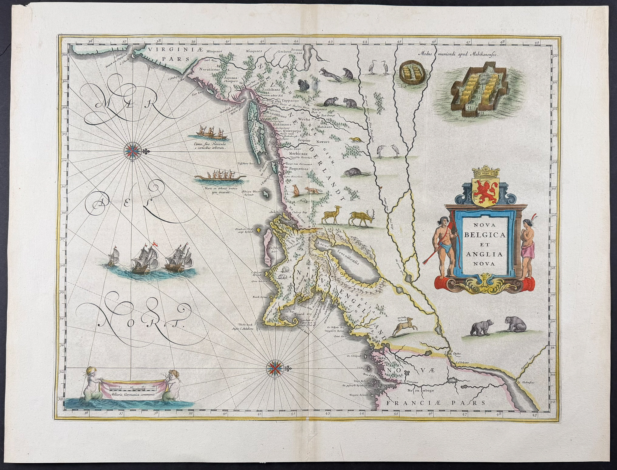
This is an important map by Blaeu depicting the Dutch and English Colonies in North America. It is one of the earliest depictions of the European colonies in North America based on Adriaen Block’s 1614 manuscript.
It was one of the earliest printed maps to designate the region between Cape Cod and Manhattan as Nieu Amsterdam, to depict Manhattan as an island, and to include the names Manhates and Nieu Nederlandt. According to Burden, Blaeu’s map departs from Block’s manuscript in several notable respects. The colony of Nieu Pleimonth is identified, and Cape Cod is refined—reconnected to the mainland by the removal of the narrow strait present in Block’s version. The coastline between this peninsula and Narragansett Bay, though recognizable, is rendered with less precision. Adriaen Block’s Eylandt leads to the Versche Rivier (the Connecticut River), which he had mapped as far inland as possible. ’t Lange Eyland is named but misplaced too far to the east, perhaps corresponding to Fishers Island. De Groote Bay denotes what is now Long Island Sound. The Hudson River, though still unnamed, is shown dotted with Dutch settlements, and the defunct Fort Nassau appears here as Fort Orange. The course of the river is more accurately drawn, and Blaeu separates the sources of the Hudson and Delaware Rivers—resolving an earlier confusion. Nieu Amsterdam is correctly depicted as a fort at the southern tip of an island, separated to the east by the Hellegat (East River). The coastline south of Sandy Hook also shows notable improvement.
Among the most visually engaging maps of the seventeenth century, this work is richly embellished with wildlife—deer, foxes, bears, eagles, hares, cranes, and turkeys—alongside beavers, skunks, and otters, which appear here for the first time on a printed map. The surrounding seas are enlivened by sailing ships and compass roses, while the title and scale are framed within elegant decorative cartouches.
Only a single state of this map is known, issued in various editions of the
Theatrum Orbis Terrarum with Latin, German, Dutch, or French text. According to Burden and Van der Krogt, the present example was published in the French edition, Le Théâtre du Monde, issued between 1635 and 1658.
Willem Janszoon Blaeu (1571-1638), Jan’s father, founded the famous Blaeu cartographic firm in Amsterdam. He studied astronomy and science under Tycho Brahe. He established a globe and instrument making business in 1599 which soon expanded into cartography publishing. It became one of the most important publishing firms in the world that was also later run by his sons Cornelis and Jan. Their maps are noted for their fine engraving process, coloring, and design and are often referred to as "the highest expression of Dutch cartographical art." He also served as the official cartographer for the Dutch East India Company in 1630.
Joan (Johannes) Blaeu (1596-1673) began the publication of the Nuevo Atlas in 1659 and would eventually change the title to Atlas Mayor. It was to be his most famous atlas, and was meant to include up to 13 volumes, but only 10 volumes were ever completed as his printing house was destroyed by fire. He was also noted for the publication of the atlas Theatrum orbis Terrarum.
Paper Size: ~ 23 5/8" by 17 7/8" (Fold Out)
Paper Type or Special Features: Originally Hand-colored Engraving
Condition report:
The work is in very good to excellent condition. There may be a few minor imperfections or faint fox marks to be expected with age. Please review the image carefully for condition and contact us with any questions.
Share this lot: