
Antique Prints, Maps, & Books of Natural History, Botanicals, & More
Lot 8045:
Description
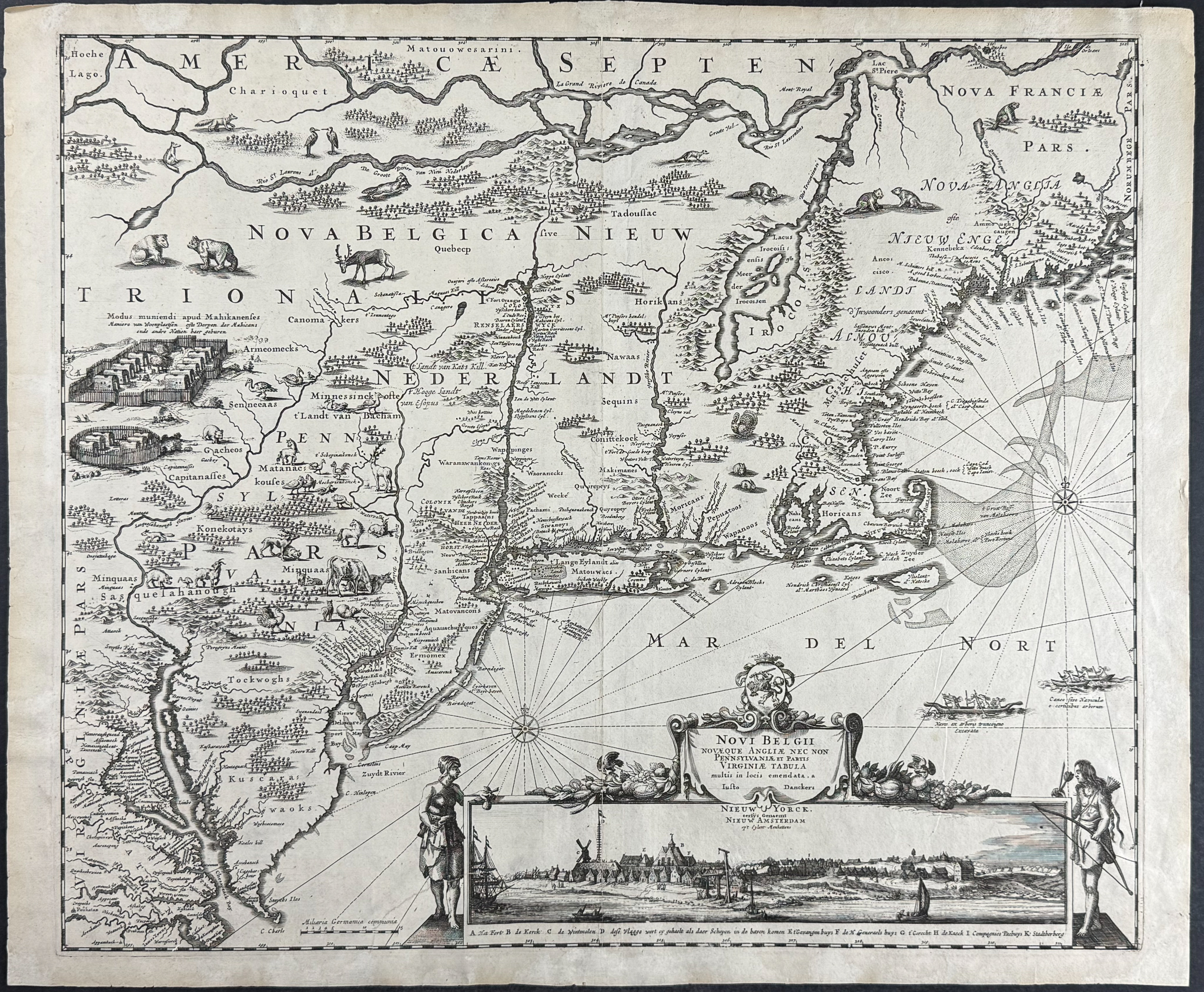
This exceptional map of north eastern America is Justus Danckerts’s
Novi Belgii Novaeque Angliae nec non Pennsylvaniae et partis Virginiae tabula multis in locis emendata. The map was published in Amsterdam circa 1684.
This is the second state of an important early map of America or New Netherlands. It is derived from Visscher’s map in 1655, which took inspiration from Jansson’s of 1651. It shows the coastal area of Northeastern America with Virginia up to Canada. It shows most of New England and an inset view of New Amsterdam [Nieuw Yorck] (now New York, Manhattan Island, second ever published view). It shows native wildlife, indigenous settlements, and ships.
Philip Burden notates that the second state is important due to it "Following the founding of Philadelphia a revised state was produced … Danckerts updated the map in a significant manner. The Delaware River is completely revised so that it no longer connects with the Hudson River … Pennsylvania is named, its boundary is marked, and many largely domestic animals are engraved within the region. Recognition of the English hold over New Amsterdam is seen in the addition to the title of the view of [the words]Nieuw Yorck, eetÿs Genaemt above. … Along with the addition to the view title … the main [title] … has had [the words] Pennsylvaniæ, et partis added as the third line." (Burden, II pp.39-40)
Justus Danckerts (1635-1701) was a Dutch engraver and publisher. He established a publishing house with his family in Amsterdam publishing his first atlas in 1686.
Paper Size: ~ 19 1/2" by 23 1/2" (Fold Out)
Paper Type or Special Features: Engraving
Condition report:
The work is in very good to excellent condition overall. There are some minor expert repairs. There may be a few minor imperfections or faint marks or fox marks to be expected with age. Please review the image carefully for condition and contact us with any questions.
Share this lot: