
Antique Maps & Prints: Natural History, Travel & Exploration
Lot 56460:
Jean-Baptiste Bourguigon D'Annville & Guillaume-Nicolas Delahaye
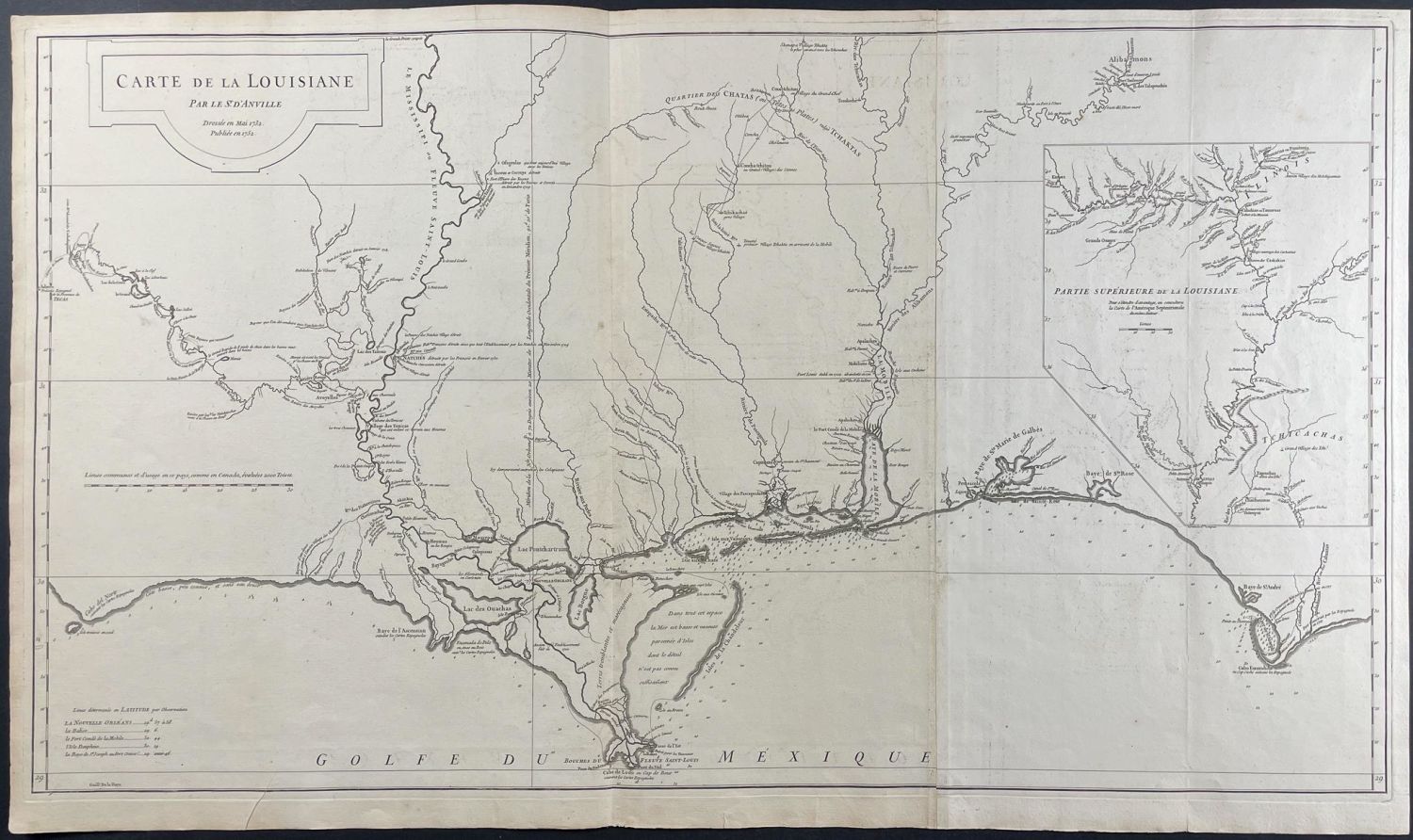
This fine engraved map of Louisiana is from Jean-Baptiste Bourguigon D’Annville & Guillaume-Nicolas Delahaye and is entitled "Carte de la Louisiane." It was published in Paris in 1752. D’Annville drew the map while Delahaye was responsible for the engraving. D’Annville based this map on manuscript maps provided by Valentin Devin as part of the 1719 expedition of Compagnie d’Occident (Company of the West, also known as the Mississippi Company).
This is one of the earliest and best large format maps illustrating Louisiana. It details much of the Louisiana coast, the Mississippi Delta, and part of the Gulf of Mexico. It shows Spanish Texas to the west and French Louisiana to the east. It shows the flow of the following rivers in nice detail: Mississippi, Missouri, Osage, Red, and Arkansas. The Mississippi River is also further detailed in an inset.
The map is aso important for historical context. It mentions the first French colony established along the mouth of the Mississippi in 1699 by Pierre le Moyne d’Iberville; the later built Fort Maurepas on Biloxi Bay and then Fort d’Iberville. These had been abandoned by the time he published but gave context. He also notes establishments that were destroyed by the Natchez people in 1729-1730 near Fort Rosalie.
Jean-Baptiste Bourguignon d’Anville (1697-1782) was a leading cartographer in the 1700s. He became ordinary geographer of the King in 1719. His maps were known for accuracy, leaving space blank when knowledge was insufficient of an area. He has a collection of maps bought by Louis XVI that is now housed in the Department of Maps and Plans of the National Library of France since 1924.
Guillaume-Nicolas Delahaye (1727-1802) was a prolific map engraver, likely producing near 1200 maps in his lifetime. He was a highly sought after engraver in cartography.
Dimensions
~ 37 1/2" by 22"
Condition
The work is in very good to excellent condition overall. There may be a few minor imperfections or faint marks to be expected with age. Please review the image carefully for condition and contact us with any questions.
Share this lot: