
Antique Maps & Prints of Natural History, Botanicals, & More
Lot 7259:
Description
This rare world map is from
Le Mer des Histoires or
Sea of Histories. The work was published in Paris in 1550 by Les Angeliers & Jean Real for Oudin Petit.
The work was first published in 1475 as
Rudimentum Novitiorum. It was noted for containing the first printed maps depicting land forms and countries. It was translated to French beginning in 1488 by Pierre Le Rouge. New woodblocks were created for the French translation in 1488 and again in 1491 reduced slightly. The 1491 woodblocks were used through to the 1555 publication.
The work was an expansive encyclopedic chronicle from the Creation of the World to the present date. It featured maps, events, and genealogies of kinds and popes. This particular edition "follows the 1544 edition, without the events from 1536 to 1543 in the last quire mm6 of the second part, reprinted in Jean Le Gendre’s ‘Third Book, ‘ and completed up to the entry of King Henry II into Blois on November 27, 1550." (Bibliography of 16th-century Parisian editions, [Online], no. BP16_114182)
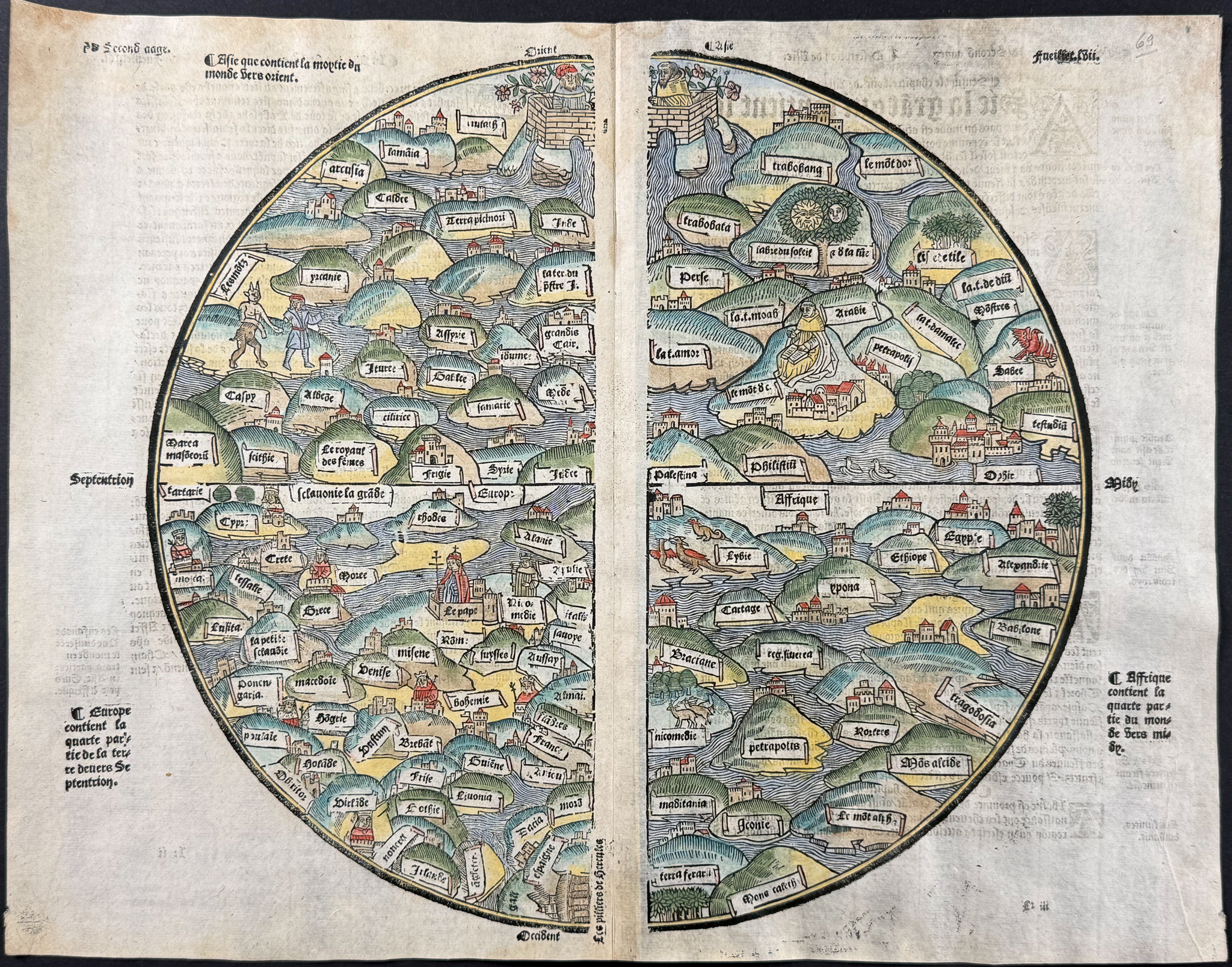
This medieval world map is oriented with the east at the upper edge and centered on Jerusalem and Palestine. It focused on Christian traditions to mapping the world over Ptolemaic or Portolan sources. The map extends to Taprobana, Ethiopia, Tartary, and the Sea of Amazons. It shows the Pope in Rome, the Pillars of Hercules, religious figures in a garden (presumably Eden, but not Adam & Eve). It also features illustrations of cities, animals including dragons, and the mythological figure of Pan.
The map is a T-O map. This type of map was first introduced by Isidorus Hispalensis in 1472. Rodney Shirley describes the T-O model with the following: "By medieval times the globular form of the earth was recognized by most scholars and geographers. World maps of the Middle Ages were often expressed in the form of simple climatic diagrams (e.g. in the works of commentators such as Macrobius, Sacrobasco, or Lilius) or conceived as one of the numerous "T-O" maps. In these examples the O represents the boundary of the world, the horizontal stroke of the T the meridian running from the Don to the Nile, and the perpendicular axis (the T-O maps invariably being oriented with east at the top) the line of the Mediterranean. T-O maps appeared in manuscripts from the early Middle Ages, and the very first printed world map, from a version of the seventh-century AD writer Isidore of Seville’s Etymologiae published in 1472, is of this kind."
Provenance: Some old provenance marks were present to the title page; ex libris mark of Jean Marchand
Full title of work:
Le premier volume de la mer des histoires. Auquel et le second ensuyvant est contenu tant du vieil testament que du nouveau toutes les hystoires, Actes et faictz dignes de memoire, puis la creation du monde jusques en lan Mil cinq cens… [-Tiers livre de la fleur et mer des hystoires plus celebres et memorables advenues tant en l’Asie et Affricque qu’en l’Europpe, nouvellement recuillies et ordonnees selon la progression des temps et années, par Jehan Le Gendre…, commençant en l’an mil cinq cens Trente et cinq, et continuant jusques en l’an mil cinq cens cinquante et ung…]
Paper Size: ~ 16 1/2” by 13” (Fold Out)
Paper Type or Special Features: Woodcut Engraving with Professional Hand-coloring
Condition report:
The work is in very good to excellent condition overall. There is some minor bleed through from text at verso. There is some faint toning at the edges or fold, but remarkable condition for age. Each page is joined to the center strip which attached it to the binding, which is how this map was issued. There may be a few minor imperfections or faint marks to be expected with age. Please review the image carefully for condition and contact us with any questions.
Share this lot: