
Antique Maps & Prints of Natural History, Botanicals, & More
Lot 5877:
Description
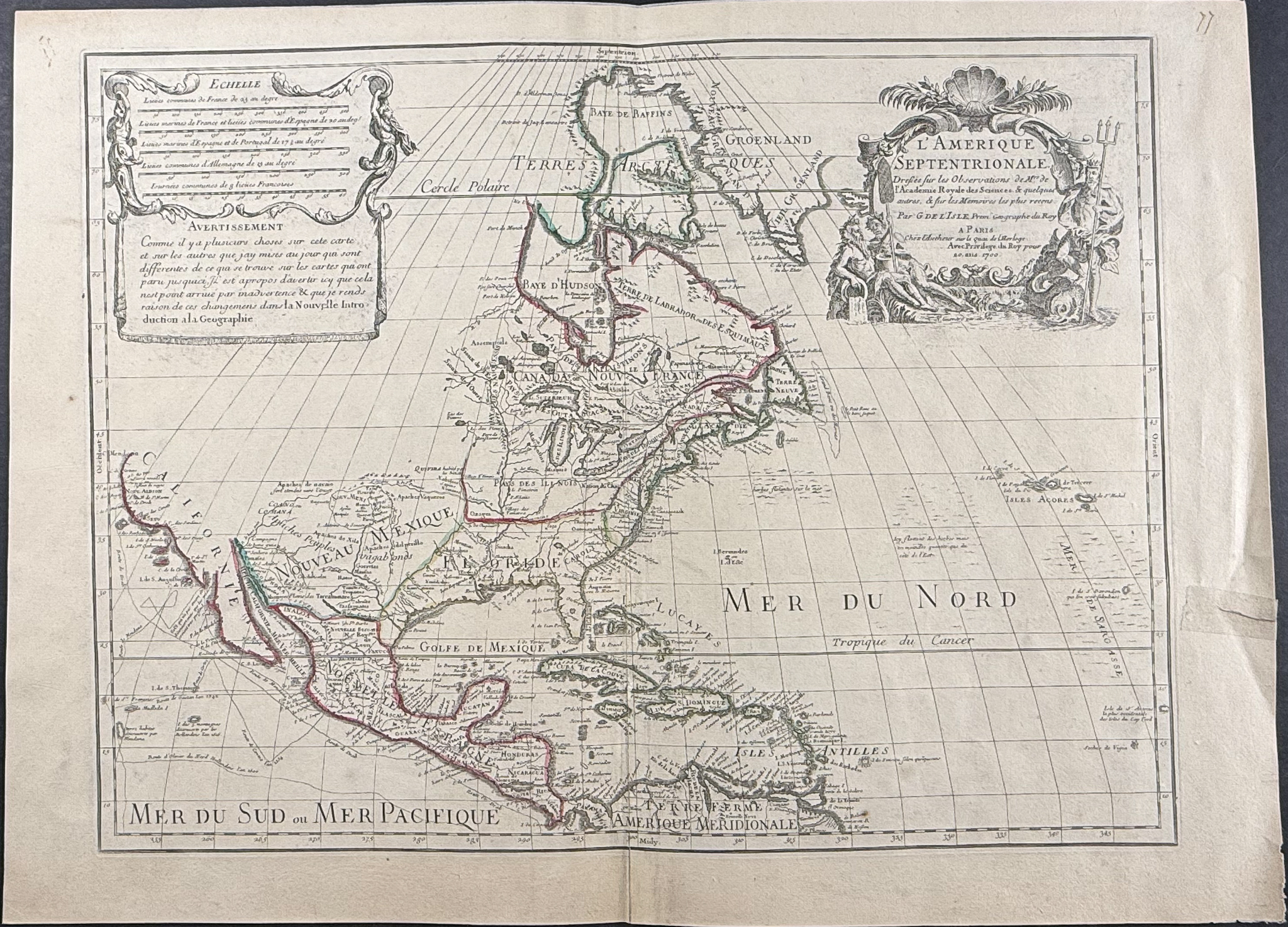
This engraved map of North America from Guillaume de l’Isle is entitled
L’Amérique septentrionale. It was published in Paris by de L’Isle in 1718. This was an important map that transformed the cartography of North America by correctly positioning the mouth of the Mississippi River.
The eighteenth century was marked by French cartographers who masterfully combined scientific precision with artistic elegance in their maps. n 1700, the father-and-son team Claude and Guillaume De L’Isle issued the first state of this historic map. It extends from California in the west to the Azores in the east, and from Greenland in the north to part of South America in the south. The map is beautifully adorned with a large, richly illustrated title cartouche engraved by Nicolas Guérard. However, it was the second state of this map that secured its lasting place in history, when De L’Isle correctly located the mouth of the Mississippi River.
Burden explains: [this English text by Burden needs to be verified if used, because this is the translation of the French description]
“… The first state shows significant differences throughout the Mississippi Valley. It was not until 1984 that the existence of the true first state became known, when it was discovered in a composite atlas in a private collection in Austria. That atlas contained the first states of each of De L’Isle’s five major maps of the Americas. Once its existence was recognized, other examples surfaced; five are known today.
Claude De L’Isle is also thought to be the author of a letter to Cassini concerning the mouth of the Mississippi. In it, he describes how, on his new map, the mouth is placed five degrees east of the Rio Bravo. This is the case on the first state, but it was altered for the second. He cites his authorities, noting that he had studied Chrestien Le Clerc’s account of Sieur La Salle’s voyages and the writings of Father Louis Hennepin. He also had access to documents from Pierre Le Moyne d’Iberville’s expedition of 1698–99—one coastal chart and two letters—as well as another map by M. de Chateaumorand, all indicating that the mouth of the Mississippi lay about 100 leagues east-northeast of the Rio Bravo. In the printed version, the identification of the Mississippi as the Spanish Rio Escondido, which appeared on the 1696 manuscript, was removed.”
Thus, the principal cartographic revisions occurred between the first and second states of the map, both published in 1700. De L’Isle relied on the accounts of Pierre Le Moyne d’Iberville, who had been commissioned by the Minister of the Marine, Louis Phelypeux, Comte de Pontchartrain, to lead an expedition to establish a French colony on the Mississippi and thereby secure control over this vital waterway. Iberville returned to France on 4 May 1699 after founding Fort Maurepas in Biloxi Bay, then returned that December to build Fort Iberville. On 4 July of the same year, De L’Isle received his first correspondence about Iberville’s expedition and obtained copies of the explorer’s and Father Anastase’s manuscript journals (Delanglez, 1943).
The information derived from these sources was incorporated only in the second state of the map, in which De L’Isle re-charted part of the Gulf Coast to include the Mississippi Delta. In addition to the Mississippi River, this map is also the first to depict the Sargasso Sea in the Atlantic Ocean. Florida is positioned far too far west of its true location—aligned with the Great Lakes, which are shown here with accurate longitudinal measurements, as is much of Canada. Many authorities have considered this map to be the first to portray California in its true peninsular form, although Burden disputes this. While California appears in its familiar shape, it is still not connected to the mainland.
Seven states of the map have been traced, the major cartographic revisions occurring— as noted—between the first and second states. Later states show typographical changes in the title imprint, reflecting successive updates to the author’s address. The present example is the seventh state, published in 1718, bearing the phrase “Prem. Geographe du Roy, ” added when Guillaume De L’Isle received that royal title in the same year.
Guillaume de l’Isle (1675-1726) was son of a cartographer and a pupil of Jean Dominique Cassini, who among other important contributions, aligned the study of astronomy to the study of geography. Under Cassini’s direction, observations were made from locations all over the world that enabled longitudinal calculations to be made with much greater accuracy. De l’Isle carried on this exacting work with remarkable dedication and integrity, constantly revising and improving his maps. While precision was his primary goal, his maps are invariably elegant and attractive. He also served as the Royal Geographer to the King of France.
Paper Size: ~ 28 7/8" by 20 1/2" (Fold Out)
Paper Type or Special Features: Engraving
Condition report:
The work is in very good to excellent condition overall. There is a closed tear with some tape repair in the right margin. There may be some faint offset due to fold out nature of the engraving. There may be a few minor imperfections or faint marks to be expected with age. Please review the image carefully for condition and contact us with any questions.
Share this lot: